Adi Kailash
About Adi Kailash
Far From City: 53 kms from city center
Cost:
About Adi Kailash
Weather:
Time Required:7 days
Open Time:May-June, October-November
Best time to visit Adi Kailash
January - Lot of snow, trek not recommendedFebruary - Lot of snow, trek not recommendedMarch - Lot of snow, trek not recommendedApril - Late April onwardsMay - Great time for trekking for nature loversJune - Great time for trekking for nature loversJuly - Monsoon (Not Advised)August - Monsoon (Not Advised)September - Amazing time for trekking for adventure enthusiastsOctober - Amazing time for trekking for adventure enthusiastsNovember - Lot of snow, trek not recommendedDecember - Lot of snow, trek not recommended
How to Reach Adi Kailash
Air:Nearest Airport is Pantnagar Airport
Rail:
Take a train to Lucknow from Delhi. SHC Garib Rath from New Delhi station is the best option. The train leaves New Delhi at 10:55 am and reaches Lucknow at 6:40 pm. Board Nainital express from Lucknow to Tanakpur. The train leaves Lucknow at 8:35 pm and reaches Tanakpur at 9:25 am. Tanakpur to Dharchula is 218 Km and takes about 6 hours to reach. Taxis and buses are available to Dharchula
Road:Delhi to Dharchula is 568 km by road and takes about 9 hours to reach.
Itinerary
Day 1:Dharchula to Sirkha - 6 KmTake a two hour jeep ride across 44 Km to Narayan Ashram from Dharchula. Narayan Ashram is a quiet and serene place from where you can begin trekking towards Sirkha. It's a simple walk of 7 Km. Sirkha is at an altitude of 2560m.
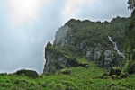
Day 2:Sirkha to Gala - 14 Km (5 to 6 hrs)As you start trekking from Sirkha, you climb through beautiful forests of flowering chestnut trees. It's an easy trail of 2 hours to the breakfast halt. After climbing for another hour, you shall reach Rolling Top which leads you to descent through quiet forests with woodpeckers and lots of langurs. The descent will take you 2 hours before you reach crossing the river in Simkhola village where you can stop for refreshments. As you walk ahead through a long winding climb, you reach Gala which is at an altitude of 2440 m.
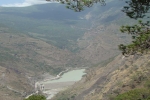
Day 3:Gala to Buddhi - 21 Km (9 hrs)The trek is long and strenuous in this part. After walking 4 km, climb down the famous 4444 steps descent to Kali river. A word of caution here - the path can become quite steep in places and the irregularly packed stones when wet due to rain, can be slippery. You can halt at Lakhanpur at the end of 4444 steps for breakfast. Here onwards, walk along the Kali river, with Nepal a stone's throw away. Be careful along the parts where the passage was too narrow. The path goes up and down a bit, and one has to be careful enough to call out when visibility is obstructed at the top of each small incline or around sharp bends. You can stop at Lamari where the yatris are treated with tea. You can stop at Malpa for lunch, where a memorial has been erected for the 1998 landslide victims. The trek onwards is filled with beautiful waterfalls. After 9 km of climbs and descents, you would be able to see Budhi at an elevation across. Go down to cross the river and climb up to reach Budhi at 2680 m.
Day 4:Buddhi to Gunji - 19 km (5 to 6 hrs)The trek is a steep climb to Chialekh, taking between 45 minutes to 1.5 hours. The path is mostly stone packed and is like a steep ramp with steps in between. There are three rest shelters along the climb, but these shelters are unkempt. You can halt at Chiyalek for breakfast at Annapurna restaurant, a small structure capable of holding 10-15 travellers. The ITBP checkpoint lies 200 m from Chialekh. The path through Chialekh was mostly flat and was along a narrow meadow which hung on a flat shelf of the hillock between steep rockfaces both above and below the meadow. The meadow is full of beautiful flowers during spring. After a sharp descent to Gharbyang, walk a flat terrain along river Kali for about an hour to reach the lunch point at Sipti. From here, it's an easy walk to Gunji at an altitude of 3220 m. Cherish the amazing view of Annapurna peak in Nepal from Gunji, provided your luck with the weather.
Day 5:Gunji to Kutti - 19 Km (7 hrs)The trek is smooth with marvellous views till Nabhi, after which there is a rocky patch. Walk through Bhojpatra forests across the river to reach Rampa, where you can stop for lunch at a hut, which seems like a blessing in the middle of nowhere. The final climb along the last 4 Km is populated, where you come across an ITBP post. As you go on across two gorges, you shall reach the tents of camp at Kutti at 3600 m.
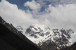
Day 6:Kutti to Jolingkong - 14 km (6 hrs)As you start trekking from Kutti, you may come across several patches of snow depending on the weather conditions. After climbing an elevation of over 3000 ft, you can marvel at the view of Chota Kailash, much before you reach camp. The trek is simple, but high altitude may cause nausea or breathlessness. You can reach Jollingkong (at an elevation of 4572 m) in 6 hours.Start early from Kutti to reach by lunch, so that you can spend the afternoon trekking to and fro GauriKund. You can refresh and ponder over the view of Chhota Kailash while lying down on the flat in front of camp at Gaurikund.
Day 7:Jolingkong to Adi Kailash/ Parvati Sarovar - 4 Km (1 hour)
Have an early breakfast at Jollingkong and start the trek for the day. Climb the hill to the Sarovar and temple. Weather conditions may play foul in catching the view of Adi Kailash in the Sarovar, but the magnificence of Chhota Kailash against the blue sky doesn't reflect anyone. There is a temple near the lake, which is sometimes visited by swan-like birds. You can come back to Jollingkong and have enough time to get back to Kutti the same day after relaxing and beholding the sights on offer. The trek downhill to Dharchulla follows the same track.
Comments on Adi Kailash
Post Your Comment