Jadh Ganga Trek
About Jadh Ganga Trek
Far From City: 42 kms from city center
Cost:
About Jadh Ganga Trek
Weather:
Time Required:7 days
Top Hotels near Jadh Ganga Trek
Find Cheap Hotels
Ananda In The Himalayas
Staring from
INR 35,328
Hotel Yog Vashishth
Staring from
INR 2,200
Zostel Rishikesh
Staring from
INR 399
View All Hotels near Jadh Ganga Trek
About Jadh Ganga Trek
Base Camp :Bhairon Ghati
Difficulty :Moderate Gradient
Highest point of trek :5230 m
Nearest Airport :Jolly Grant Airport
Nearest Railhead :Rishikesh, Haridwar
Region :North Uttarakhand, Garhwal Himalayas
Starting point of trek :Bhairon Ghati
Itinerary
Day 1 : Bhairon Ghati to Karmoli
Distance: 15 kms , Duration: 7 hours
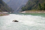
On your first day of trek, you begin your journey by driving a few kilometers from Bhairon Ghati. Soon you will be trekking along the left banks of Jadh Ganga River, the trail going upwards amid a beautiful dense forest of Deodar. During the trek, you will be crossing a number of brooks finally arriving at the campsite near the Chaudhar Stream for the night. A spectacular view of ice wall in form of Chaudhar Ridge is breathtaking.
Day 2 : Karmoli to Naga
Distance: 12 kms , Duration: 7 hours
The second day of the trek is fascinating enough to lure you back to the place. After a steady trek of three hours, you will arrive at Dhumku. On the other side, a thrilling sight of Chor Gad nalla joining the Jadh Ganga with great roar is a treat the eyes. From here, a path goes up to reach the source of Bapsa River, where you can cross the Yamrang La to reach Tibet. After trudging along for few kilometers, a beautiful view of Kalidhang (6375 m) will welcome your sights while passing along Neelang. Another 2 km in to the trek and you will arrive at Log Bridge, which you will be crossing in order to avoid vertical rock cliffs. Soon you will encounter Guli gad merging with Jadh on to the left side of the bank. Traverse the river just before Naga where Jadh and Nilapani fuse together.
Day 3 : Naga to Sonam
Distance: 11 kms , Duration: 6 hours
Today, from the valley loaded with vegetation you enter a region with very scant vegetation, land being dry and familiar to Tibet landscape. After a steep ascent of 3 kms, you will finally reach a place from where begins descent through vast grazing fields leading to the left banks of River Jadh; the river here if quite wide and is referred to as Sonam. After covering this thrilling track, you have finally reached your campsite offering enticing views of Chibas Parbat (6252 m).
Day 4 : Sonam to Pulamsunda
Distance: 20 kms , Duration: 8 hours
On your fourth day of trek, the trail will pass through a rocky terrain alongside the left bank of river. Make sure you cross the river before the Jadh merges with Rongmach gad towards the right bank and then cross again 2 kms after Tirpani, this time towards the left bank. Here, the river is much calm and clear. You will also encounter a huge ITBP. After trudging for some time you will finally reach the campsite near Baregudda Stream, about 8 kms ahead of Pulamsunda.
Day 5 : Trekking options to the nearby peaks
The fifth day of the trek is a strenuous one with lots of options on the way. Begin the trek with a climb or a trek towards small glacial lake perched at an altitude of 5770 m through several 6000 m or more peaks in the proximity. Some of the many nearby peaks include Tsangchok la (5350 m), from where Harrer escaped into Tibet; Thag La (5030 m), Tsangchok La, Kinnaur Raniso La (4055 m), Khimokul La (4557 m), Kinner kailash (6474 m), Reo Pargial (6791)- Muling La (5584 m) ,Sri Kaila (6932 m) and Mana Parbat (6794 m) etc. The pace is flanked by the triangle of Kamet (7756 m) on the Southern East along with its neighbours Mukut Parbat (7244 m) and Abi Gamin (7357 m). Savour the beauty of the magnificent landscape all around before heading for the campsite of Pulamsumda.
Day 6 : Pulamsunda to Sumla
Distance: 3 kms , Duration: 2 hours
Today you will be heading towards Sumla Village from Pulamsunda trekking for about 3 kms. Being the trek along the river side till you reach the place where the stream of Mendimerges with Jadh. This also your campsite for the day. However make sure to pitch your tents on to the right side of Mendi.
Day 7 : Sumla to Tsangchokla back to Pulamsunda
Distance: 20 kms , Duration: 9hours
This is your last day of the trek when you will ultimately be heading back towards Pulamsunda in the end. Commence the last day with trudging along the Mendi Stream right up to its source climbing steadily. Continue travelling until you reach pass, 200 m below at the site of ruined walls. Ascend steadily from here on towards the pass marked by cairns over the pass itself where you will come across a 2 m high chorten. The view all around is awe inspiring with coloured mountains, screes and schist. You will be able to enjoy a better view by descending about a hundred meters. The verdant grazing ground of village adds charm to the raw beauty of the place. Make sure you have relished the panoramic surrounding and captured its essence in your camera to its best. Soon it's time to retrace your steps back to Pulamsunda and then to Karmoli.
Top Tourist Places in Rishikesh
Lakshman Jhula
Neelkantha Mahadeva Temple
Geeta Bhawan
Rafting in Rishikesh
Triveni Ghat
Bungee Jumping in Rishikesh
All Tourist Places in Rishikesh
Comments on Jadh Ganga Trek
Post Your Comment