Meesapulimala
About Meesapulimala
Far From City: 39 kms from city center
Cost:
About Meesapulimala
Weather:
Time Required:3-4 hours
Meesapulimala Trek
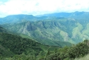
The Meesapulimala Peak is situated at an elevation of 2640 m above sea level making it the second highest peak in the Western Ghats. The day begins with a jeep ride along the roads of Munnar amidst the tea plantations and thick forests as well as pine plantations till the silent valley which is the starting point of the trek. As you pass, you will experience the lush woods on the way. Trekking through the forests, you will come across the shola forests which will offer panoramic views of the landscapes.
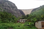
The trail is hilly and passes along the edges of the Western Ghats with numerous ascends and descends. You will then reach a point where the view will get hidden under the blanket of clouds. The peak gives a mesmerising view of the Anayirangal Dam, Tamil Nadu and the Kolukkumalai plantation which is the highest tea estate in the world. All the adventure lovers are going to enjoy this 6-7 hour experience.
Best time to visit Meesapulimala
The highest trekkable path situated in the Western Ghats, the perfect time to visit Meesapulimala is after the monsoon season gets over from October to February since during this time the jungle looks even more beautiful after getting its energy. Throughout the trail, you will be accompanied by birds, water streams, and flowers.
How to Reach Meesapulimala
Meesapulimala is situated 42 km away from Munnar and 21 km away from Chinnakanal. This distance can be covered via the Suryanelli-Kolukkumalai Tea Estate Road. One can also trek to the destination all the way from Kurangani. The difficulty level of the trek ranges from moderate to difficult, and a total of 15 km needs to be covered one-side to reach the destination.
Top Tourist Places in Idukki
Gavi
Idukki Arch Dam
Painavu
Kulamavu Dam
Thommankuthu Falls
Nandukani
All Tourist Places in Idukki
Photos of Meesapulimala

Comments on Meesapulimala
Post Your Comment