Sopore
About Sopore
Far From City: 88 kms from city center
Cost:
About Sopore
Weather:
Time Required:2-3 hrs
Open Time:Business units : Mon-Fri : 10 am-4 pm, Sat : 10 am-2 pm, Sun : Off
About Anantnag Sopore
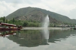
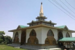
Sopore town, founded Sopore in 880 AD during the rule of King Avantivarman, lies at a distance of 48 km from the district of Srinagar on the banks of the River Jhelum. It is the biggest trade centre of the North Kashmir region and is known among tourists as the apple town of Asia. The town of Sopore is famous for the Jamia Masjid, Khan-Kah Shah-i-Hamdan and several small shrines. Sheikh Hamza Makhdoomi Tujar, Arza Sahib Takya Khan Zainagair, Daid Mouj Mundji, Baba Shukur Din Watlab Sopore, Hathi-Shah Sahib are some of the other popular shrines located in Sopore. (br) Anantnag, locally known as Islamabad, is a district in the Indian state of Jammu and Kashmir. It is one of eight districts which make up the Kashmir Valley. The district headquarters is Anantnag city. As of 2011, it was the third most populous district of Jammu and Kashmir (out of 22), after Jammu and Srinagar.
Administration and Tourism
Anantnag district comprises Kokernag, Shangus, Anantnag (town), Bijbehara, Doru, Pahalgam and Qazigund tehsils. The district consists of seven blocks : Breng, Shangus, Achabal, Dachnipora, Qazigund, Khoveripora and Shahabad. Each block consists of a number of panchayats. (br) The district consists of many tourist places like, Verinag, Achabal, Kokernag, Daksum, Pahalgam,Dandipora (under process), Chatabal, Martand and Sinthan top. Of these places, Pahalgam and Kokernag are the famous and often visited places just 50 km from Anantnag Town. (br) Amarnath Temple, a famous shrine in Hinduism dedicated to Shiva is located in Phalgam. It is the site of an annual pilgrimage, Amarnath Yatra.
Road facility
Anantnag has following roads connecting it to various assembly segments and with NH1A ( Major District Roads)
*NH1A Khanabal to Sangam via Bijbehara
*NH 1B Khanabal to Kishtwar via Achabal, Akingam, Kokernag
*Verinag Anantnag Road
*Larkipora Fatehpora Road
*Sadura Kamad Road
Climate
Anantnag features a moderate climate Koppen climate classification. Anantnag's climate is largely defined by its geographic location, with the towering Karokaram to its east and the Pirpanjal range to the south. It can be generally described as cool in the spring and autumn, mildin the summer, and cold in the winter. As a large city with a significant difference in Geo location among various districts, the weather is often cooler in the hilly Areas of east as compared to the flat northern part of anantnag. (br) Summer is usually mild and with a little rain, but relative humidity is generally high and the nights are cool. The precipitation occurs throughout the year but no one month is particularly dry. The hottest month is July (mean minimum temperature 6 °C, mean maximum temperature 32 °C) and the coldest are Decemberâ??January (mean minimum temperature -15 °C, mean maximum temperature 0 °C). (br) Weather conditions are unpredictable. The record high temperature is 33 °C and the record low is -18 °C. On 5â??6 January 2012, after years of relatively little snow, a wave of heavy snow and low temperatures shocked the city covering it in a thick layer of snow and ice, forcing them to officially declare a state of emergency and calling the following two days (6 and 7 January) off for the whole valley.
Availability of bon fire and barbecue locations
Bon fire and barbecue locations available but is low on wi-fi and online network.
How to Reach Sopore
Well connected via city trains and roadways as well as airways in the parallel vicinity.
Top Tourist Places in Anantnag
Amarnath Ji's cave
Kishtwar national park
Aishmuqam Shrine
Jhelum River
Kherbawani Asthapan
Masjid Baba Dawood Khaki
All Tourist Places in Anantnag
Tips
Always carry warm and cozy clothes while travelling in here. It takes 2 hours, 3 minutes to travel from Sopore to Anantnag. Approximate driving distance between Sopore and Anantnag is 104 km.
Comments on Sopore
Post Your Comment